Submitted for the record
Questions for the Record — Storage, Setbacks, and the Approved Area
Planning and Zoning Commission · September 21, 2026 · Magruder asphalt plant, 50 Roelker Road
To: Chairman and Members of the Planning and Zoning Commission; the Zoning Officer; the Building Official; the City Clerk, for the record
From: Dr. Jackie D. Ramey, 701 Seaside Drive, Wright City, Missouri
Date: September 21, 2026
Members of the Commission, thank you for your service and for the time you give this community.
I cannot say the Board got anything wrong on June 11. You cannot tell that something is out of order until you can see the order. Nothing in that packet said a conformity determination was missing, and it took more than a year of records requests to learn what was not there.
Tonight you have the plat, and §410.010(I) asks whether it conforms. That question is yours, and it is the first time anyone has been in a position to answer it.
This memorandum asks a single question in twelve parts: does the approved operation fit within the area that was approved? Every fact below comes from the City’s own production or from the applicant’s filings with the Missouri Department of Natural Resources. I am not asking the Commission to decide anything tonight. I am asking that these questions be entered in the record and answered in writing.
The situation in three sentences
The June 11, 2026 approval covers a plant block the plans label “About 5 Acres.” Condition 3 excludes the adjoining area labeled “Future Asphalt Plant Expansion and Aggregate Storage Area.” An asphalt plant cannot operate without aggregate storage — so the material either sits in the excluded area, or it sits in the five acres and must be measured against the Code’s open-storage limit.
1 · The storage area changed, then disappeared
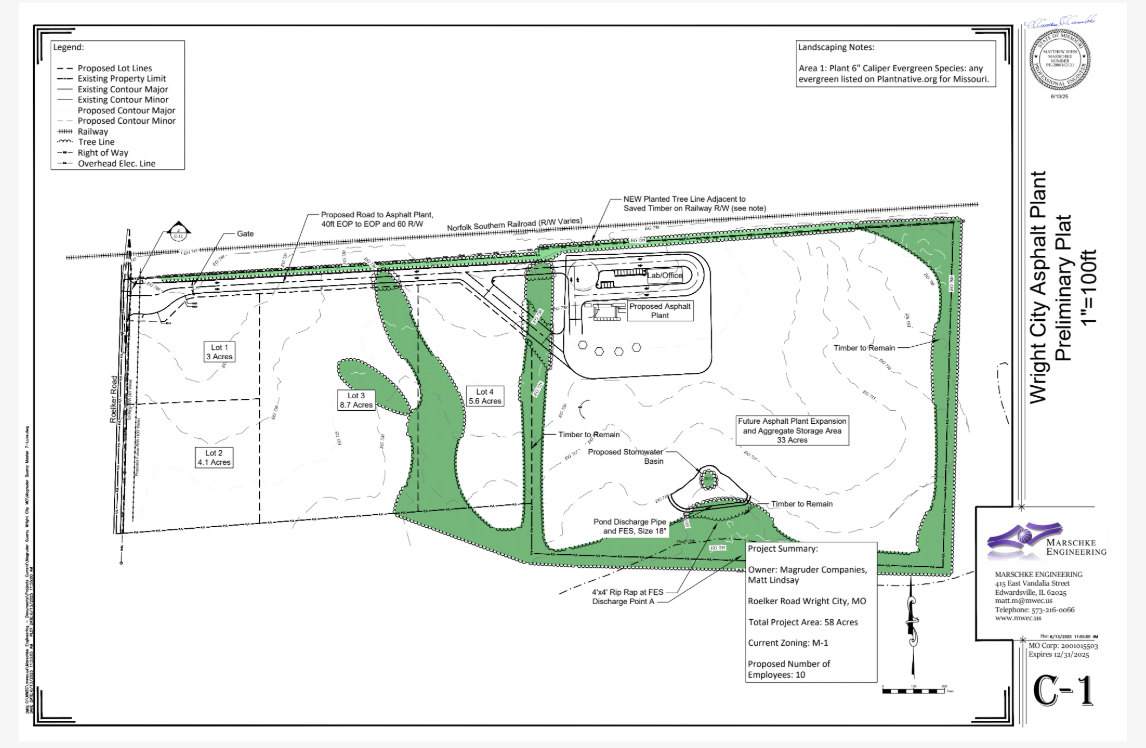
June 13, 2025 — the set furnished to this Commission for its August 18, 2025 meeting. Sheet C-1 labels “Future Asphalt Plant Expansion and Aggregate Storage Area — 33 Acres.”
January 29, 2026 — the set the Board approved on June 11, 2026. The same area is now 36.4 acres on Lot 5 — 3.4 acres larger than what this Commission saw.
July 8, 2026 — the current revised set. The aggregate storage area does not appear at all, and no lots are labeled. Sheet C-2 shows only “Projected Asphalt Plant (10 Employees) (About 5 Acres).”
Question 1.1
Where, on the plan as it now stands, is aggregate to be stored? If the answer is the excluded Lot 5 area, the operation depends on ground the approval does not cover. If the answer is within the five acres, where is it shown?
2 · What the operation requires
From the applicant’s own filings with the State:
1.5 acres of storage piles — DNR technical review, Permit 032010-001AK
13,000 tons of material stored year-round: 8,000 rock, 2,000 sand, 3,000 RAP — SWPPP §3.1
72,000 gallons of liquids in bermed tanks: 50,000 liquid asphalt, 15,000 burner fuel, 7,000 diesel — SWPPP §3.1
400 tons per hour maximum design rate; a 120 MMBtu/hr drum dryer; a 3.5 MMBtu/hr asphalt heater — DNR technical review
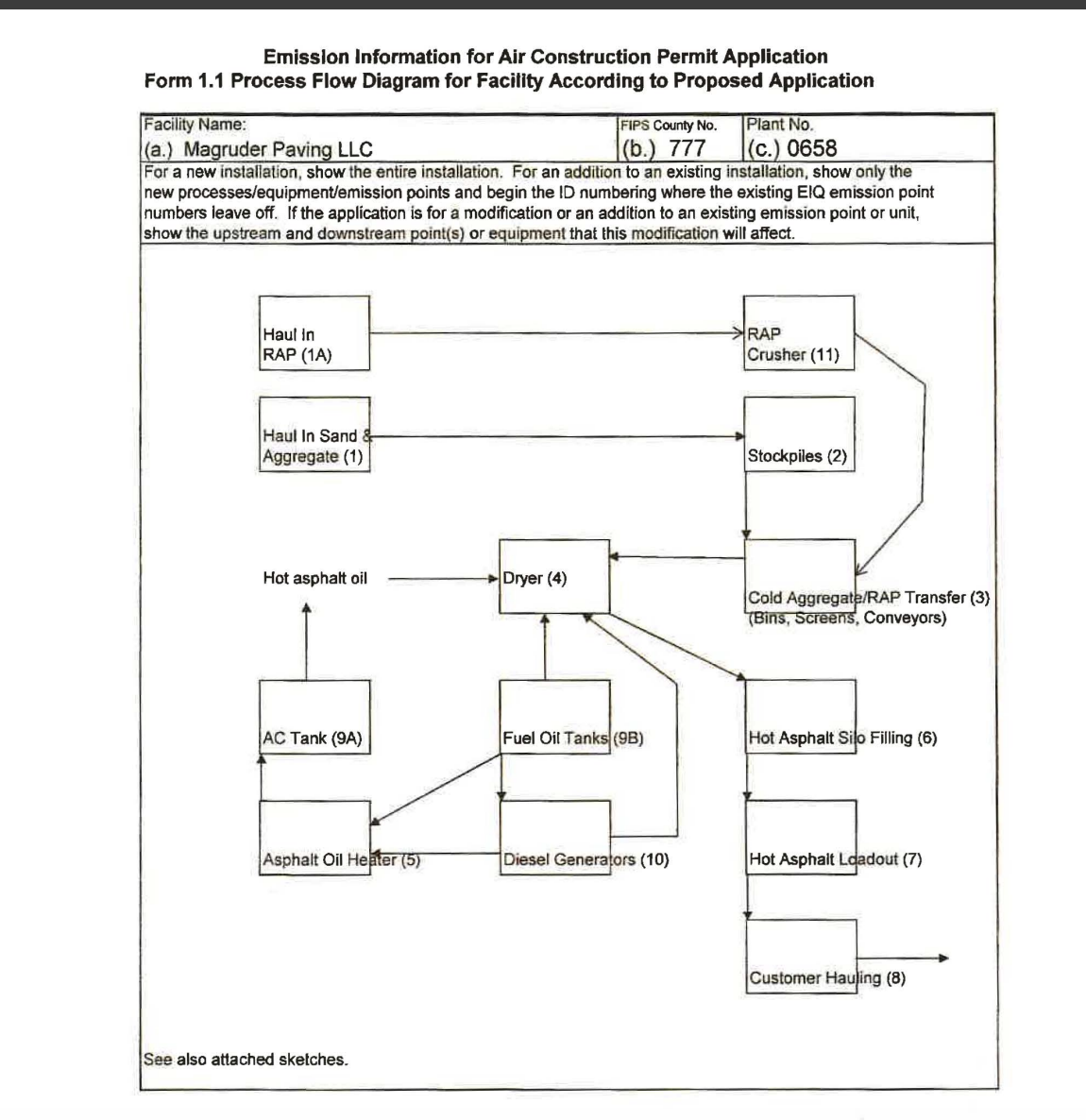
Equipment: drum dryer, silos, stack, crusher, asphalt heater, diesel generators, AC tank, fuel oil tanks — DNR Form 1.1
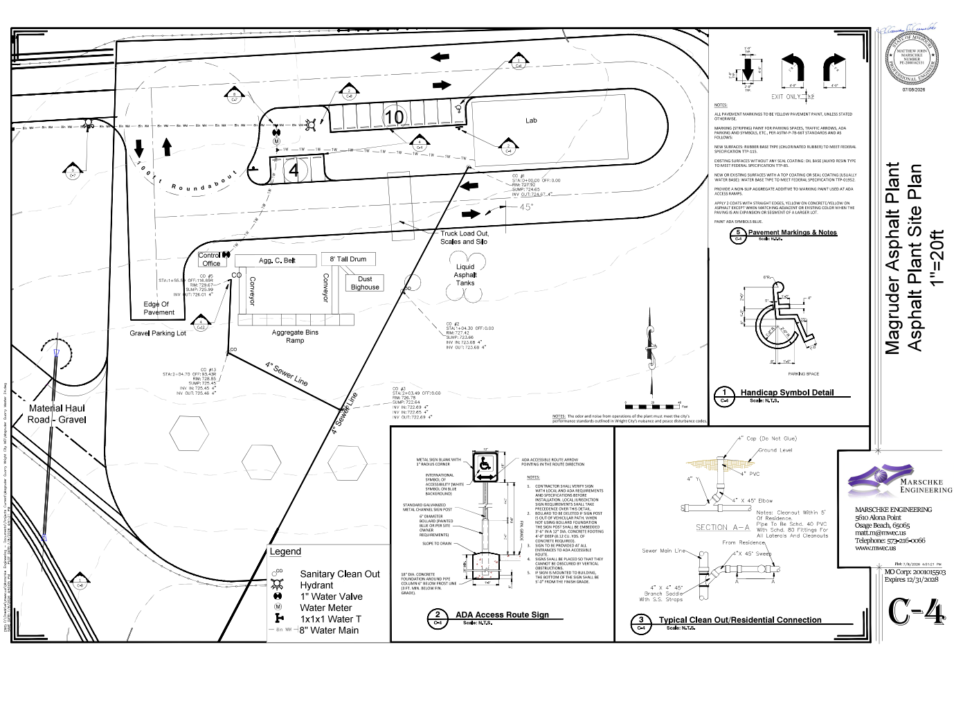
Of the equipment listed above, Sheet C-4 of the current set draws three — the drum, the silo and the AC tank. The stack, crusher, asphalt heater, diesel generators and fuel oil tanks do not appear on it. And none of these quantities, capacities or ratings appears on any plan set the City holds: not the tonnages, not the 72,000 gallons, not the MMBtu ratings, not the 1.5 acres of piles. The applicant’s site map filed with the State shows the stockpiles as a separate area set 200 feet from the plant; no plan sheet shows that area at all.
Question 2.1
Did the City receive, at any point, an equipment list, a capacity schedule, or dimensions for this facility — or was the use classified and the site plan approved from drawings alone?
The plans regulate stockpiles the plans do not show
The approved January 29, 2026 set carries this note: “Stockpile heights must not exceed 35 feet.” That note tells us the applicant’s own approved set contemplated real, worked piles — not a hypothetical future use. On that set the only ground provided for them was Lot 5, the 36.4-acre “Future Asphalt Plant Expansion and Aggregate Storage Area” — which is precisely the area Condition 3 declined to approve. On the current July 8 set that location is gone altogether, while the operation it served is unchanged.
The dimension matters. Thirteen thousand tons is roughly 8,700 cubic yards. Storing that volume within the 1.5 acres the State record identifies requires piles on the order of twenty-five to thirty-five feet high — which is presumably why the set caps them at thirty-five. These are not low yard areas. They are piles three stories tall that must be worked by loaders throughout the operating day, and the current set places them nowhere.
Volume arithmetic is ours, from the SWPPP tonnages and the plan set’s own height limit.
A portable authorization, and a permanent foundation
The approved set includes a “Concrete Thickness” detail, referenced to Sheets C-7 and C-8, appearing alongside the equipment labels for the silo, drum, tanks, bins ramp and conveyors. The structural notes in the same set call for exterior slabs at 4,000 PSI, footings that “may be designed for solid rock” with special inspection, and anchor bolts with reinforcement placed “between bolt and surface for containment.”
What the record does not say is how those details relate to the plant equipment — whether the silo, drum and tanks are founded on a concrete pad, and if so to what dimension. That question matters because the State authorization for this plant is a portable source relocation permit, PORT-0658 / 032010-001AK, whose Special Condition 6 bars operation at this site for longer than twelve consecutive months. A permanent installation and a portable plant are two different descriptions of the same facility.
Which one the City reviewed matters, because a permanent structure on a foundation is subject to the height and setback provisions of §405.520 and §405.540 and requires a building permit, while a portable characterization may be understood to avoid them.
Question 2.2
Was this facility reviewed as a permanent structure or as a portable plant? Please identify the concrete pad and foundation detail by sheet and detail number, and state whether a building permit and a structural review are required for the equipment anchored to it.
Question 2.3
The approved set limits stockpile heights to thirty-five feet. Where on the current plan are those stockpiles located, and what area was that limit written to govern?
3 · The limits that were never calculated
§405.560(A)(5)(b) — open storage may not exceed 40% of the lot, and storage areas carry surfacing and drainage requirements.
§405.560 — buildings may not cover more than 75% of the lot.
§405.520 and §405.540 — industrial structure height, and additional setbacks where structures exceed 30 feet and adjoin residential zoning. The only height stated anywhere in the record is the “8′ Tall Drum” labeled on Sheet C-4. No height appears for the silos, the stack, the aggregate bins or the baghouse — the structures these two provisions would turn on.
The City has confirmed in writing that it holds no 40% open-storage calculation and no 75% coverage calculation, and that it is “unable to determine the specific records being requested” for the document fixing the plant’s location and setbacks within Lot 5.
For scale: five acres is 217,800 square feet. A 40% cap allows about 87,100. The 1.5 acres of piles the State record requires is about 65,300 — roughly three-quarters of the entire open-storage allowance, leaving the remainder for the plant, the tanks and containment, the lab and control offices, the scale, fourteen parking spaces, internal drives, and three stormwater basins, before any setback is subtracted.
Question 3.1
Which lot were the 40% and 75% limits measured against, and what were the results? If the calculation was never performed, on what basis was compliance with §405.560 determined?
Question 3.2
Sheet C-4 states one height, an 8′ drum. What are the heights of the silos, the stack and the tanks, and was §405.540 applied? If those heights were never provided to the City, how was the setback requirement evaluated?
And what consolidation does to those same limits
Both caps are percentages of the lot. The plat before the Commission makes the lot fifty-eight acres. On about five acres, the 40% cap allows 2.0 acres of open storage and the 75% cap 3.75 acres of coverage. On one 58-acre lot the same two limits become 23.2 acres and 43.5 acres — an increase of 11.6 times, produced by the plat itself rather than by any change to the Code.
The 1.5 acres of piles the State record requires is three-quarters of the allowance on five acres, and six and a half percent of it on fifty-eight.
Question 3.3
After consolidation, against what lot area will the §405.560 limits be measured — the whole 58 acres, or some smaller area? If a smaller area, what record establishes its boundary?
4 · The boundary the approval rests on
The approved plant area has no legal description, no metes and bounds, no coordinates, and no recorded instrument locating it within the larger property. The surrounding property is described variously as 5 acres, about 8 acres, 33 acres, 36.4 acres and 58 acres depending on the record. The consolidation plat that would establish a single legal parcel was submitted twelve days after the vote and remains unapproved — it was tabled by this Commission on August 17, 2026.
Question 4.1
What record defines the boundary of the area in which asphalt-plant operation is authorized, and how can a five-acre limitation be enforced if that boundary has never been drawn to a dimension?
5 · Was stormwater review ever complete — on June 11, on August 17, or today?
BFA Engineering to the City, forwarded by the City Clerk · August 28, 2026
“It is our understanding that the developer has not yet submitted final construction plans as part of the building permit review process. As a result, BFA has not reviewed any subsequent or final SWPPP or other construction plans.”
That is the City’s own engineering consultant, eleven weeks after the approval. Read backward, it means stormwater review was not complete on any of the three dates that mattered:
June 11, 2026 — the day the site plan was approved. The minutes record that stormwater plans “were reviewed by BFA and would be no impact to the creek.” The review BFA had actually completed was its sixth, dated February 10, 2026, and that letter directed that Sheets C-2 and C-5 be updated “with submittal of final plans.” No final plans existed.
August 17, 2026 — the day the consolidation plat came before this Commission. Still no final plans and no final SWPPP review. The Building Inspector’s July 15 plat review had already left the Chapter 412 stream-buffer question open, and it remained open that night.
August 28, 2026 — and so far as the record shows, today. BFA states plainly that nothing further has been submitted or reviewed.
The question that follows from this: was the Board of Aldermen aware, on June 11, 2026, that the stormwater review it was told had been completed was in fact a preliminary review of an earlier plan set, expressly conditioned on final plans that had never been submitted? And was this Commission aware of the same thing on August 17?
Question 5.1
Have final construction plans and a final SWPPP now been submitted and reviewed? If not, what is the status of the Chapter 412 stream-buffer determination, and should the plat proceed while that review is incomplete?
6 · No permit may issue until the conditions are met
The June 11, 2026 approval is conditional on its face. Condition 1 requires an updated site plan reflecting the relocated turn lane, road widening and entryway “prior to any building permits being issued.” Condition 2 requires a boundary-adjustment plat consolidating the six lots into one, approved by the City and reflecting the 90-foot right-of-way dedication, “prior to any development or building permits being issued.”
On the record as it stands: the consolidation plat was tabled by this Commission on August 17 and has not been approved. Final construction plans have not been submitted. No final SWPPP has been reviewed. The City confirmed on August 6, 2026 that no permits of any kind have issued for this site — which is consistent with the conditions.
Question 6.1
Who determines that a condition has been satisfied, and is that determination recorded in writing? As of today, has any of the five conditions been found satisfied — and if so, which, by whom, and on what date?
Question 6.2
Given Conditions 1 and 2, can any grading, land-disturbance, building or development permit lawfully issue before the consolidation plat is approved and the updated site plan accepted? If the City’s view is that some permit may issue on a separate track, what provision authorizes it?
7 · The fuel storage, and what proceeding this belonged in
Section 405.510(A)(5) addresses the storage of flammable gases and liquids as a conditional use in the M-1 and M-2 districts, rather than a use permitted by right. This site is proposed to hold 50,000 gallons of liquid asphalt, 15,000 gallons of burner fuel and 7,000 gallons of diesel — 72,000 gallons in bermed tanks, stored year-round, per the applicant’s own SWPPP. Sheet C-4 notes “Liquid Asphalt Tanks” without capacity, containment dimensions or setback — and that is the only tank group on the sheet. Form 1.1’s point 9B, Fuel Oil Tanks and point 10, Diesel Generators are not drawn anywhere, so the 22,000 gallons of burner fuel and diesel appear on no plan sheet at all, nor does any berm or containment. The City has confirmed in writing that no conditional-use application exists for this project.
I recognize that fire and building codes distinguish flammable liquids from combustible ones by flash point, and that the three liquids here may fall into different classes. That is precisely why I am asking rather than asserting. The question is what determination the City made, and under what provision.
Question 7.1
What determination was made under §405.510(A)(5) for this project, and how was each of the three stored liquids classified? What definition or referenced fire code did the City apply?
Question 7.2
If §405.510(A)(5) applies to any of this storage, what authorized the project to proceed as a site plan rather than through the conditional-use process, with the notice and public hearing that process requires?
There is a sequencing problem in this that bears on Monday specifically. Whether §405.510(A)(5) reaches any of these liquids depends on what each one is — its flash point and its classification. The record does not identify them. Until the fuel type is known, neither the storage requirement nor the proceeding this belonged in can be determined by anyone reading the file, including the Commission.
Question 7.3
What are the specific products and flash points of the 15,000 gallons of burner fuel and the 7,000 gallons of diesel, and where is each shown on a plan sheet with its containment? If the products have not been identified to the City, how was any storage or classification determination made without them?
The same August 18, 2025 agenda carried two conditional use permits — AutoZone at 441 North Service Road West and the Fire Protection District at 60 Bell Road. The AutoZone item received a noticed public hearing. The asphalt plant was taken up under New Business as a site plan, with no hearing. Understanding what distinguished them would help the public understand how the Code is applied.
8 · Paved surfaces, and what a condition can and cannot cure
§405.110(C)(1), “Off-Street Parking and Loading Requirements,” states without qualification that “all driveways and access points to public or private streets shall be paved.” The current plan sheets label a “Gravel Parking Lot” and a “Material Haul Road — Gravel,” and Sheet C-2’s Site Legend carries a “Gravel Limit” alongside Concrete and Asphalt Limits. In fairness to the record, the entrance itself is specified as paved — Sheet C-6 calls for 2.5″ asphalt over 8″ of clean rock. The open question is the parking lot and the haul road.
The exceptions to that subsection are narrow: existing residential gravel driveways; residential driveways connected to private gravel roads; a conditional use permit “to allow heavy steel track equipment storage on gravel”; and “biodegradable product inventory and materials” in industrial districts. Nothing on this site is residential. The heavy-equipment route requires a conditional use permit, and the City has confirmed in writing that no such application exists. Rock, sand and liquid asphalt cement are not biodegradable.
The City applied this subsection differently seven months before this project. On January 16, 2025 it published a notice, signed by the City Clerk, for a Board of Adjustment hearing held January 29, 2025, in which an applicant on Star Connection Drive sought “a variance from the paving requirement of the Wright City Zoning Code, Section 405.110.C.1 … to allow gravel surfaces for a proposed asphalt batch plant.” Same subsection, same use type, a noticed public hearing at which neighbors could speak.
Question 8.1
Which exception under §405.110(C)(1) applies to the gravel parking lot and the gravel material haul road shown on the current sheets — identified by subsection? If none applies, what record establishes that this plat conforms to the Zoning Code as §410.010(I) requires?
Conditions of approval are not a conformity determination
Two different things are easily treated as one. Conditions 1 through 5 are what the Board of Aldermen attached to its June 11, 2026 site-plan vote — administrative conditions on that application. §410.010(I) asks a different question: whether the plat conforms to the Zoning Code, meaning the standards in Chapter 405.
A condition can restrict what an applicant may do. It cannot make a nonconforming feature conforming, because the standard is not the Board’s to waive. The Code names two routes to relief, and both run through a different body with notice and a public hearing: a variance from the Board of Adjustment, or a conditional use permit. Neither appears in this file.
Condition 3 is a withholding. It declines to approve the future expansion and storage area. Declining to approve one thing is not a determination that what remains conforms.
Question 8.2
If the response to any question in this memorandum is that the conditions on the June 11, 2026 approval address the matter, please identify the provision under which a condition of site-plan approval cures a nonconformity with Chapter 405 for purposes of the §410.010(I) conformity determination.
9 · Why this plat cannot be found conforming on the present record
Every standard that establishes conformity is measured against a lot — setbacks, the 40 percent open-storage cap, the 75 percent coverage cap, and height under §405.520 and §405.540. The plat is what creates the lot. The measurements can therefore only be made against the parcel this plat records, and no measurement of any kind exists in the file for any lot configuration, past or proposed. That is the City’s own written answer of August 6, 2026, not a characterization offered here.
Ordinarily that circularity is closed by the plat itself, which carries the dimensioned information — the boundary of the operating area, the storage location, the setbacks. This plat does not. The Building Official’s July 15, 2026 review under §410.010(G) identified the same class of defect: an unlabeled tract, missing state-plane coordinates, and an unresolved Chapter 412 stream buffer.
On one standard the record is not merely silent. §405.110(C)(1) requires paving; the sheets show a gravel parking lot and a gravel material haul road; and there is no variance and no conditional use permit. That is not an open question but a nonconformity on the face of the drawing, and for the reasons in Section 8 a condition of approval cannot cure it.
And the fuel cannot be resolved at all until the products are identified, because the classification determines which provision applies. Approving the plat does not answer any of this. It records a 58-acre parcel that has never been measured against the Code.
The conformity determination §410.010(I) calls for cannot have been made at the June 11 vote, because at that point there was no consolidated lot to measure against. This meeting is the first point at which the lot and the conformity question exist together — which is why the determination has to be identified now rather than assumed.
Question 9.1
Against what measurements, contained in what document, would the Commission find this plat in conformity with the Zoning Code as §410.010(I) requires? If no such measurements exist, on what basis can that finding be made tonight? §410.010(I) requires conformity with all Zoning Code provisions for the district, which is a broader question than the lot-dimension test in §410.010(G)(1) — if the July 15, 2026 review concluded the plat “appears to comply,” comply with which provisions, measured against what?
10 · Who makes the conformity determination, and when does the appeal period run?
§410.010(I) requires conformity with the Zoning Code before record-plat approval. It does not say who makes that determination. On the Code as I read it, this Commission reviews the plat and makes a recommendation, and the Board of Aldermen takes final action. A determination that this plat and the development shown with it conform to the Zoning Code is an administrative act, and the Code provides a route for reviewing administrative acts.
Wright City provides that the City Planner or City Administrator may issue written interpretations of Chapter 410, and that those interpretations may be appealed to the Board of Adjustment. §400.040 gives the Board of Adjustment authority to hear an appeal by a person aggrieved by an order, requirement, decision or determination made by the Code Official or another official in enforcing the zoning code, within 60 days of the action appealed. Missouri §89.110 then allows 30 days after the Board of Adjustment’s decision is filed to petition the Circuit Court of Warren County.
In July the City’s written position was that no administrative zoning determination had been made, and therefore that there was nothing for the Board of Adjustment to review. If that is still the case tonight, then the determination §410.010(I) calls for has not been made by anyone, and this Commission is being asked to recommend a plat on a conformity finding that does not exist. If it is no longer the case, the date matters, because the appeal period runs from it.
Question 10.1
Who is making the administrative determination that this boundary-adjustment plat and the development shown with it conform to the Zoning Code under §410.010(I), and where is that determination documented?
Question 10.2
If that determination has already been made by the Zoning Enforcement Officer, City Planner, Building Official or City Administrator, what is the date of that determination, so that an aggrieved person may exercise the appeal rights provided by §400.040 and §410.010(E)?
Question 10.3
If no administrative determination has been made, what zoning determination is the Commission relying upon in recommending a plat that §410.010(I) requires to conform?
Why I am asking this of staff rather than of the Commission
A recommendation by this Commission is not itself the kind of decision the Board of Adjustment reviews; Missouri authority holds that the Board of Adjustment generally has no jurisdiction over the actions of an elected Board of Aldermen simply because those actions concern zoning. The reviewable act is the administrative determination the recommendation rests on. That is why the question tonight is not what this Commission decides, but who has determined conformity and on what date.
Either answer completes the record. If an official has made the determination, it can be identified and reviewed in the ordinary way. If none has been made, that should be stated, so that no one later assumes the question was answered at a stage where it was not asked.
Section and deadline references above are given as I read the adopted Code and §89.110; the City’s own reading of them, stated on the record, is part of what this question asks for.
11 · Outside approvals the record does not show
Fire district. The applicant’s engineer wrote to the Building Inspector on June 28, 2025 that preliminary approval had been obtained from the fire department. When records of that review were requested, the City produced the Fire Protection District’s own station site plan and conditional-use application from the same agenda — a different matter. No fire review of this plant appears anywhere.
Railroad. The plans contemplate a water line crossing beneath the Norfolk Southern right-of-way. No crossing permit, encroachment agreement or easement appears in the record.
Water district. Public Water Supply District No. 2 reviewed and approved the water infrastructure in January 2026 as “25-080 · Magruder Asphalt Plant — 5 Lots — Approved for Construction” — the same five lots Condition 4 states were never created and are “conceptual only.”
State air authority. DNR Authorization 032010-001AK states that authority to operate at this site expired April 1, 2026, and Special Condition 6 bars operation at the site longer than twelve consecutive months.
Other Missouri cities require these confirmations before the site plan is approved, not after. Maryland Heights, for example, requires verification of approvals from the applicable fire district, MoDOT and the Department of Natural Resources prior to site plan approval.
Question 11.1
Which outside agency approvals does the City treat as prerequisites for this project, which have been received, and does the water-district approval remain valid once the five lots become a single tract?
A word about what is being asked, and of whom
The same thing is true of the first site plan as of this one. The sheets that came before this Commission in August 2025 did not show the drum, the silo, the stack, the tanks or the stockpiles. A volunteer Commission cannot reasonably be expected to ask about the height of a stack it has no reason to know exists. Knowing which questions an asphalt plant raises comes from experience with asphalt plants.
Magruder has that experience, and already holds every figure at issue. The tonnages, the 72,000 gallons and their classifications, the equipment list, the heights and the 1.5 acres of storage are set out in the company’s own filings with the State — its DNR application, its Form 1.1 and its SWPPP. Supplying them to the City is not a burden. It is a copy of what the applicant has already written down elsewhere.
That is the whole of the request. Complete the record, so that the area that was approved can be shown to hold what the operation actually requires, and so that nothing needing a conformity determination is left off the drawing.
12 · What I am asking
Why the five acres matters
No record explains where the five acres came from. The label “About 5 Acres” is the applicant’s, printed on Sheet C-2. Condition 3 is the City’s, and it does not set a five-acre limit either — it simply declines to approve the Lot 5 expansion and storage area. The five acres is what was left over, not a boundary anyone drew.
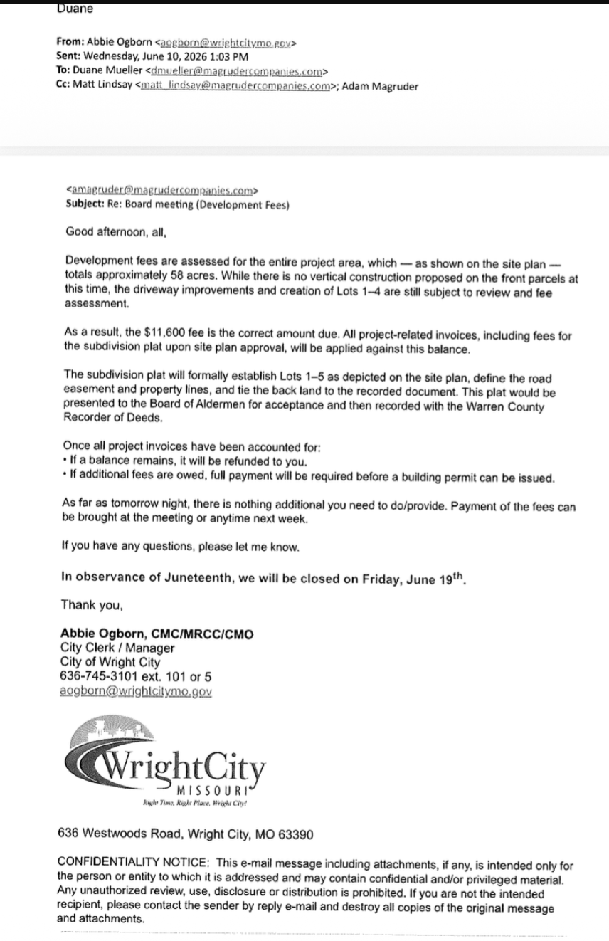
Meanwhile the site has moved in one direction. The storage area grew from 33 acres to 36.4 between the set this Commission reviewed and the set the Board approved. The City charged development fees of $11,600 calculated on the “entire project area” of approximately 58 acres — treating the whole property as the project for money while approving five acres for use. And the plan labels the balance “future expansion,” with an amended site plan promised later.
A small approval now, a larger one later, each step modest against the one before it. Planners call this creep, or piecemealing — a project reviewed in parts, so that no single review ever confronts its full scope. That sequence is a concern here for one specific reason: the storage the plant needs today was placed in the part that was deferred. If the deferred area is where the aggregate goes, then the expansion is neither optional nor future. It is required for the approved plant to operate at all, and the Commission has never reviewed it as such.
What the Code required of this applicant, and when
Two provisions point to the same proceeding. §405.510(A)(5) makes the storage of flammable gases and liquids a conditional use in the M-1 and M-2 districts rather than a use permitted by right. §405.110(C)(1) allows gravel in place of pavement for heavy equipment storage only by conditional use permit. Neither application was ever filed, and the City has confirmed in writing that none exists.
This was not a matter of not knowing. Magruder runs asphalt plants. The company knew what its own operation required — which fuels, in what quantities, on what surfaces, in how much space — and had already set every one of those figures down in its filings with the State. The conditional use permit is the proceeding designed to put exactly those facts before the public, with notice and a hearing. That proceeding did not happen.
The result is that the project reached its final approval without the hearing the Code contemplates for these things, and without the figures that hearing would have put on the table. That is the condition the record is in tonight.
How other Missouri cities handle this
Wright City is not unusual in having these requirements — it is unusual in how they were applied here. Three comparisons, all from Missouri municipal codes:
Plattsburg requires site plan review for the expansion of any existing use, and defines “expansion” to include a floor space increase of twenty-five percent or more within any ten-year period, or the introduction of new materials or processes not previously associated with the existing use. Adding a process triggers review, not just adding square footage.
Maryland Heights requires verification of necessary approvals from the applicable fire district, MoDOT and the Missouri Department of Natural Resources prior to approval of the site plan. Here, the site plan was approved with no fire district review of the plant in the record, and with the DNR portable authorization already set to expire.
Richmond Heights requires that all necessary utilities be available, functioning and usable at the time any stage of the project, or the total project where constructed as a whole, is ready for occupancy — language that permits staged construction while still measuring each stage against the whole.
In states with environmental review statutes, reviewing a project in pieces is called segmentation and is disfavored, because dividing a project can make its impacts appear smaller than they are and obscure the cumulative effect. The test those courts apply is whether the pieces can genuinely be implemented and operated independently, or whether one is a foreseeable consequence of the other. Missouri has no such statute, so that test is not binding here. But it is still the right question for this Commission to ask: can the approved five-acre plant operate independently of the deferred storage area? On the record before you, it cannot.
This is a Code question, not the lawsuit
None of what I have raised here is what is before the court. This is a storage and dimensional-compliance question under §405.560 — the same ordinance that applies to every landowner in Wright City. The City has required that kind of compliance of others: an applicant for a temporary concrete plant on Star Connection Drive was required to seek a variance from §405.110(C)(1) simply to use a gravel surface, with a public hearing noticed for January 29, 2025. That request was withdrawn. The Magruder plan shows gravel parking and gravel limits, and no variance appears in the record.
The concern is straightforward and practical: the storage this plant requires has never been located on any approved drawing. Once the equipment is in place, the material has to go somewhere, and the only ground the plans ever offered for it is the area Condition 3 declined to approve. §410.010(I) placed that question before approval for exactly this reason.
I am not asking the Commission to reach a conclusion tonight, and I am not asking anyone to prejudge the applicant. I am asking three things:
One. That these questions be entered in the record of this meeting and answered in writing.
Two. That the Commission ask staff to identify, before the consolidation plat advances, where aggregate storage is located on the current plan and how the §405.560 limits were applied.
Three. That if any of these records does not exist, the Commission ask that it be said so in writing. A clear “no record” is a complete and useful answer.
Thank you for your time and your consideration.
Respectfully submitted,
Dr. Jackie D. Ramey
701 Seaside Drive, Wright City, Missouri 63390 · 636-236-2126
Sources, all public records. Each is published at wright-city-neighbors.netlify.app and linked here:
DNR Portable Source Relocation Request PORT-0658, February 24, 2025, with Form 1.1 and the submitted site map ·
DNR Authorization 032010-001AK, March 12, 2025, technical review ·
Form 1.1 process flow · Magruder civil plan sets —
June 13, 2025,
January 29, 2026 as approved,
July 8, 2026,
Sheet C-4 detail ·
Board of Aldermen minutes and conditions, June 11, 2026 ·
City fee email, June 10, 2026 ·
Building Inspector’s §410.010(G) plat review, July 15, 2026 ·
BFA SWPPP letter and
BFA stormwater letter, February 10, 2026 · City Sunshine Law responses —
June 17,
July 20 and
August 6, 2026 ·
Final consolidation plat ·
Wright City Code §§405.510, 405.520, 405.540, 405.560 and §410.010 — the Codes in Question board.