Exhibit · prepared from the City’s own production
Does the Plant Fit on the Area That Was Approved?
Storage, setbacks, and the five acres · 50 Roelker Road, Wright City, Missouri · September 19, 2026
The question
The June 11, 2026 approval covers a plant block the plans label “About 5 Acres.” Condition 3 excludes the neighboring future expansion and aggregate storage area. An asphalt plant cannot operate without aggregate. So everything the operation needs — the plant, the tanks, the stockpiles, the ponds, the parking, the drives — has to fit inside those five acres, within the Code’s storage and setback limits.
Nobody has ever checked. The City confirmed in writing on August 6, 2026 that it holds no open-storage or coverage calculation, no setback determination for the plant area, and no record locating that area by dimension or legal description.
1What has to fit — and where it is written down
The left column comes from the applicant’s filings to the State. The right column is what the City’s own approved plan sheets show. They do not match.
Told to the State
8,000 tons rock · 2,000 tons sand · 3,000 tons RAP, stored year-round (SWPPP §3.1)
50,000 gal liquid asphalt · 15,000 gal burner fuel · 7,000 gal diesel — 72,000 gallons in bermed tanks (SWPPP §3.1)
1.5 acres of storage piles; 400 tons/hour design rate; 120 MMBtu/hr drum dryer; 3.5 MMBtu/hr asphalt heater (DNR Permit 032010-001AK)
Drum dryer, silos, stack, crusher, asphalt heater, diesel generators, AC tank, fuel oil tanks (DNR Form 1.1, plant 0658)
Of the equipment listed above, Sheet C-4 draws three: the drum, the silo and the AC tank. The stack, crusher, asphalt heater, diesel generators and fuel oil tanks are not on it. And none of these quantities, capacities or ratings appears on any plan set the City holds — not the tonnages, not the 72,000 gallons, not the MMBtu ratings, not the 1.5 acres of piles.
On the approved sheets
A block labeled “Projected Asphalt Plant (10 Employees) (About 5 Acres)” on Sheet C-2; its equipment drawn on Sheet C-4
“Liquid Asphalt Tanks” noted on Sheet C-4 — no capacity, containment dimensions, or setback
Lab/office, control office, scale, trash enclosure, 14 parking spaces, internal drives, gate
Three stormwater basins and their discharge structures
Gravel limit, asphalt limit, concrete limit hatching
Sheet C-4 draws the plant equipment at 1″=20′. What it does not draw: no aggregate stockpiles, no truck unloading area, no dimensioned plant boundary, no tank capacities or containment dimensions, and no structure heights other than an “8′ Tall Drum.”
The first two sets at least
said where the aggregate would go — a labeled area outside the five acres. The current set says nothing at all. The note is gone, and no replacement location appears anywhere on the sheet.
Current set, July 8, 2026 →
2This is not just “storage.” It is working production space.
One of the biggest issues the revised site plan needs to make clear is the amount of land actually required to operate this asphalt plant — not just where equipment or aggregate piles happen to sit.
Magruder’s own DNR process-flow diagram shows an active production system:
Trucks haul in RAP, sand, and aggregate → materials are unloaded and stockpiled → RAP is crushed → material moves through bins, screens, and conveyors → into the dryer → into the hot-asphalt silo → through loadout → and out by customer hauling.
The same diagram also identifies the AC tank, fuel-oil tanks, asphalt-oil heater, diesel generators, crusher, conveyors, dryer, silo, and loadout area.
And DNR’s Wright City technical review says this operation includes 1.5 acres of storage piles, a 400-ton-per-hour plant, a 1,720-foot raw-material receiving route, and a 1,620-foot finished-asphalt shipping route. Missouri DNR publicly identifies this as Magruder’s Wright City portable-plant permit, PORT-0658 / Permit 032010-001AK. DNR authorization and technical review → · Relocation request PORT-0658 →
Why that matters
Because 1.5 acres of stockpiles does not mean the stockpile operation takes only 1.5 acres.
Trucks have to get to those piles and unload. Loaders have to maneuver around them, scoop material, back up, turn, and transport material to the plant. RAP has to reach the crusher. Material has to reach the feed bins and conveyors. Finished asphalt trucks have to reach the loadout area and leave through the same circulation system.
DNR itself calculates emissions from the loading and unloading of the storage piles, confirming that these are actively worked areas — not passive storage sitting untouched.
So when the new site plan comes back, this is what needs to be shown. Not simply a box labeled “aggregate storage.” Sheet C-4 already draws the feed equipment, the tanks, the loadout and the circulation to scale. What it still needs to show is the 1.5 acres of actual piles plus the working space around them — truck unloading, loader maneuvering, material-transfer paths from pile to ramp, and the crusher area.
The real question is not, “Can 1.5 acres of aggregate fit?”
How many acres does the entire working operation require, once the space necessary to actually use those 1.5 acres is shown?
That is exactly what a complete revised civil site plan should make clear before conformity is determined.
The applicant’s own process-flow diagram
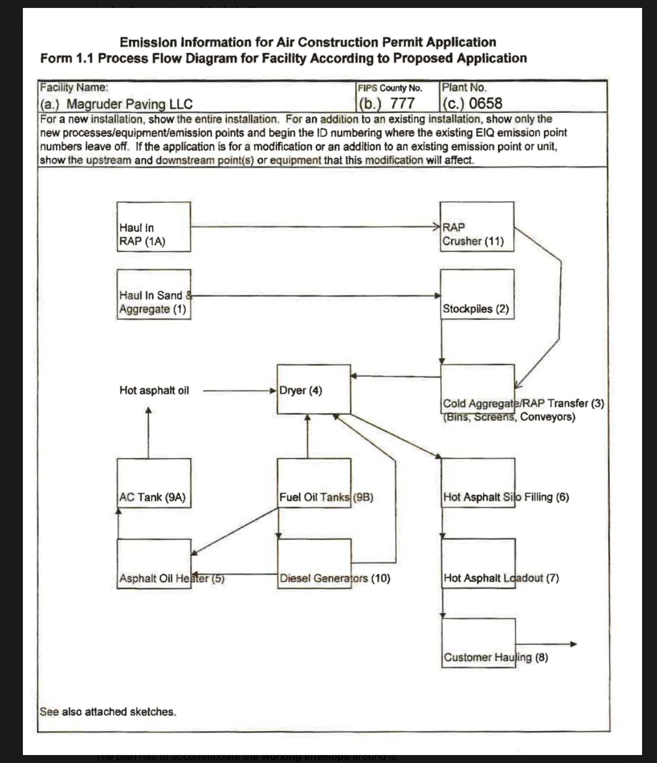
Read the numbers on that diagram
The applicant did not list trucking as something that happens near the plant. It listed trucking as
part of the plant.
Haul In Sand & Aggregate (1) and
Haul In RAP (1A) are the first process points.
Hot Asphalt Loadout (7) and
Customer Hauling (8) are the last. Every one of them is a numbered emission point in the same permit application as the dryer and the silo.
Form 1.1, page 3 →A plant is not only a building and machinery. By the applicant’s own accounting it is also the space for trucks to arrive, unload, maneuver, load, and leave. Sheet C-4 draws part of that: a 100-foot roundabout, the drive loop, the haul road and the truck load out. The unloading half is what is missing — C-4 draws an aggregate bins ramp and a gravel haul road, but no stockpile, no unloading apron, and no loader path from a pile to that ramp. The route in is drawn; the ground it comes from is not.
The same chain, in plain language
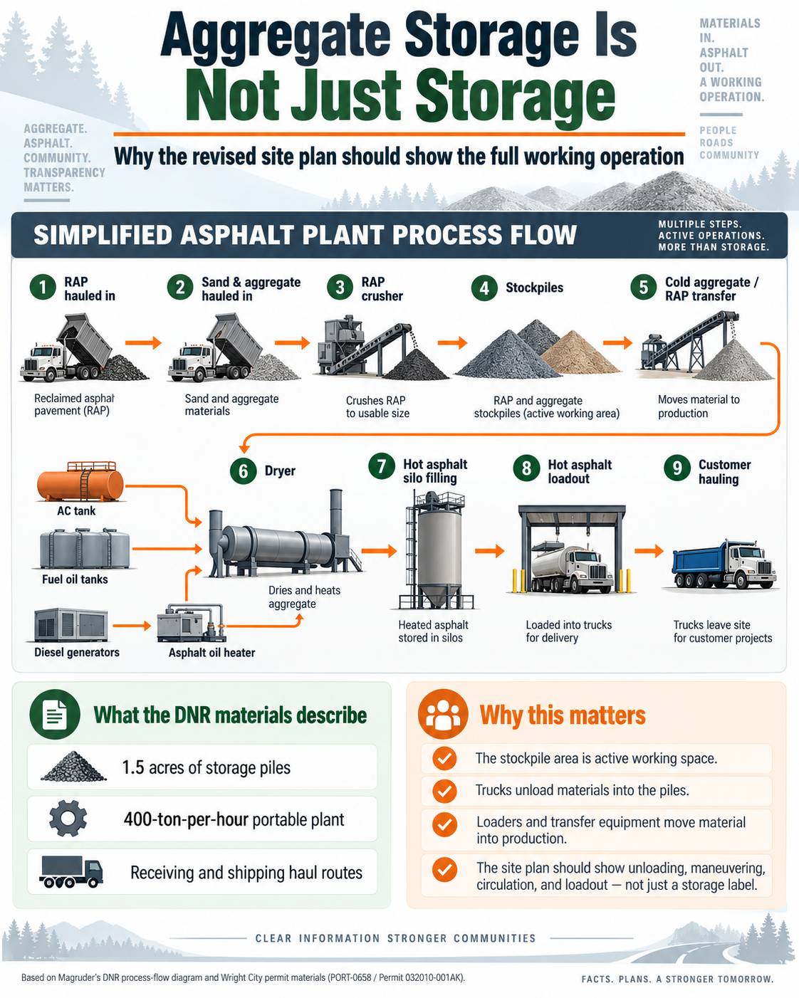
Plain-language illustration of the nine steps shown on Form 1.1. The permit application also notes “See also attached sketches,” reproduced below.
Source: Form 1.1 →
The attached sketch
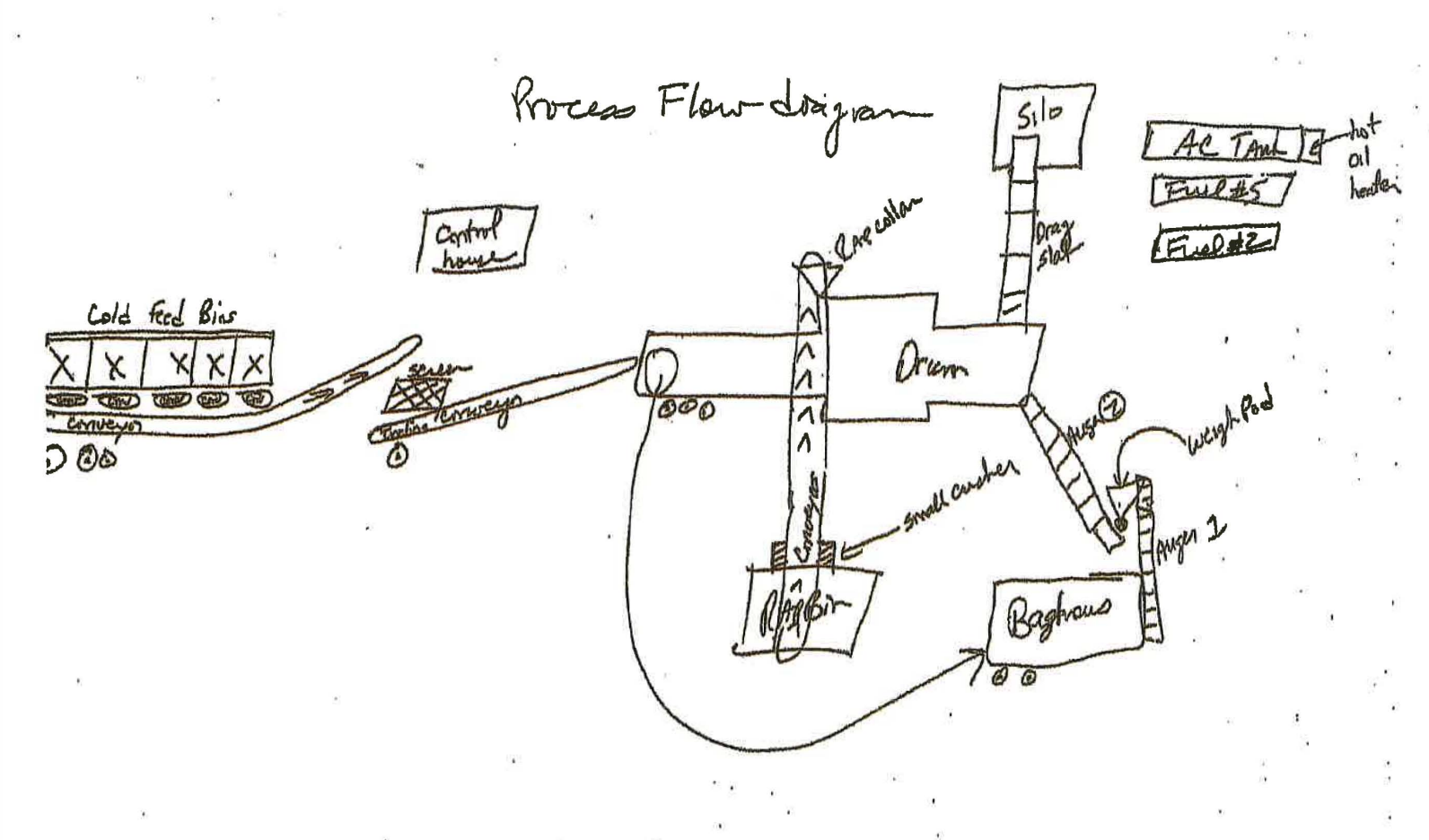
The sketch referenced on Form 1.1, showing cold feed bins, conveyors, screen, drum dryer, baghouse, augers, drag slat, silo, control house, AC tank, fuel tanks and hot oil heater.
Open the sketch in the DNR relocation request →
3The three plan sets, in order
Three sheets, three bodies, three dates. The same 58 acres each time. What changes between them is where the aggregate is allowed to sit — and whether it is shown at all.
What the Commission was looking at in August 2025
A five-acre plant, with possible growth at some point later. The sheet said so in words: a plant block, and beside it an area named “Future Asphalt Plant Expansion and Aggregate Storage Area — 33 Acres.” Future, and bounded.
What came next changed it into something else, one step at a time. The area grew by 3.4 acres and became Lot 5. Condition 4 then declared all five lots “conceptual only” — they were never created. Condition 2 directed that the six parcels be consolidated into one. The July sheet removed the storage label from the drawing altogether.
Each step reads as procedure. Together they erase the lines the Code measures against. Setbacks, the 40% storage cap, the 75% coverage cap and height are all computed against a lot — so when the lots go, so does the boundary that would have made a change in storage, or in the scope of the operation, a change requiring review.
The question is whether a five-acre plant with a named 33-acre expansion area, and a single 58-acre parcel with no storage area shown anywhere, are the same land use — and if they are not, at what point that change was reviewed, and by whom.
There is no way to answer that from the file. The plans never described the facility as it would actually operate, so there is no baseline to compare against.
Set 1 of 3
Plan set one · before Planning & Zoning, August 18, 2025
Site plans dated June 13, 2025
The sheet the Commission reviewed
Civil plan set, June 13, 2025, Sheet C-1 — the set before the Planning & Zoning Commission on August 18, 2025. Four lots labeled; the storage area labeled as an area, at 33 acres.
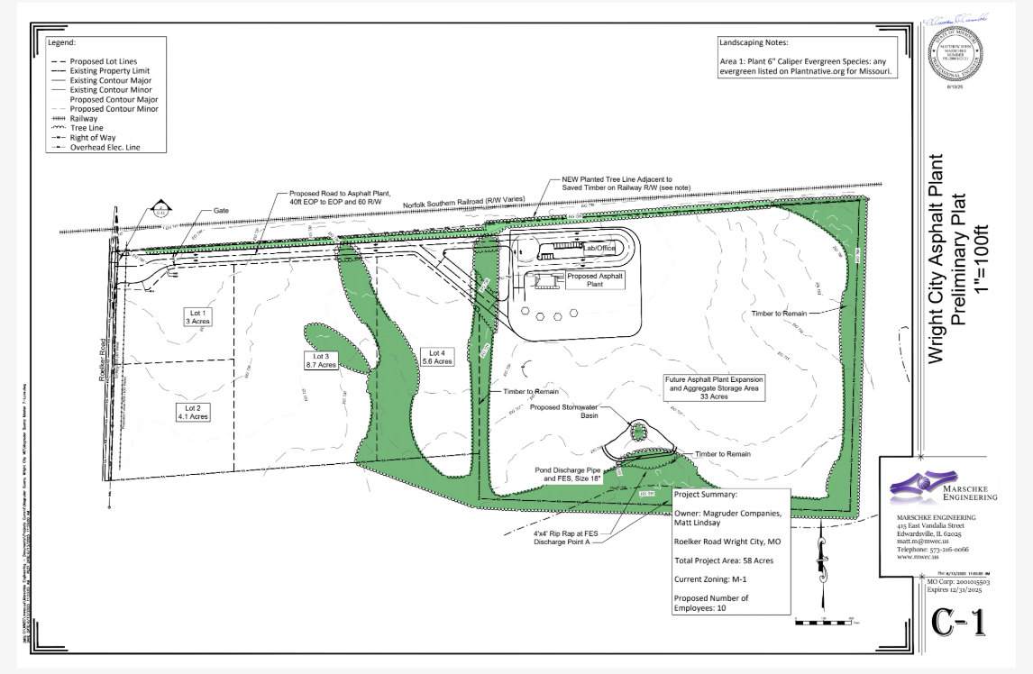
On this sheet the lots stop at four. The storage ground is not a lot at all — it is an area note reading “Future Asphalt Plant Expansion and Aggregate Storage Area — 33 Acres,” drawn southeast of the plant with no lot number.
What the Commission’s sheet added up to
Storage area — no lot no.
33
This sheet’s Project Summary already states “Total Project Area: 58 Acres” and “Current Zoning: M-1” — the same two figures that appear on the January 29, 2026 sheet a year later. The labeled areas on the face of the drawing come to 54.4 acres. The remaining 3.6 acres carry no label.
Four lots are numbered here, not five. The storage ground is an area note, not a lot — and it is the only figure on the sheet that changes before the Board vote.
What changed between the two sheets
The storage area grows from 33 acres to 36.4 acres — 3.4 acres larger than the area the Commission reviewed — and acquires a lot number it did not have. The four numbered lots are unchanged at 3, 4.1, 8.7 and 5.6 acres. The labeled total moves from 54.4 to 57.8, and the Project Summary stays at 58 both times.
Condition 3 was then written against “the note on Lot 5” — a lot number that exists on the January sheet and on no other. It was not on the set the Commission reviewed, and it will not exist on the recorded plat after consolidation.
Set 2 of 3
Plan set two · approved by the Board of Aldermen, June 11, 2026
Site plans dated January 29, 2026
The sheet the Board approved
Civil plan set, January 29, 2026, Sheet C-1 — the set the Board approved June 11, 2026. Five lots, labeled and dimensioned.
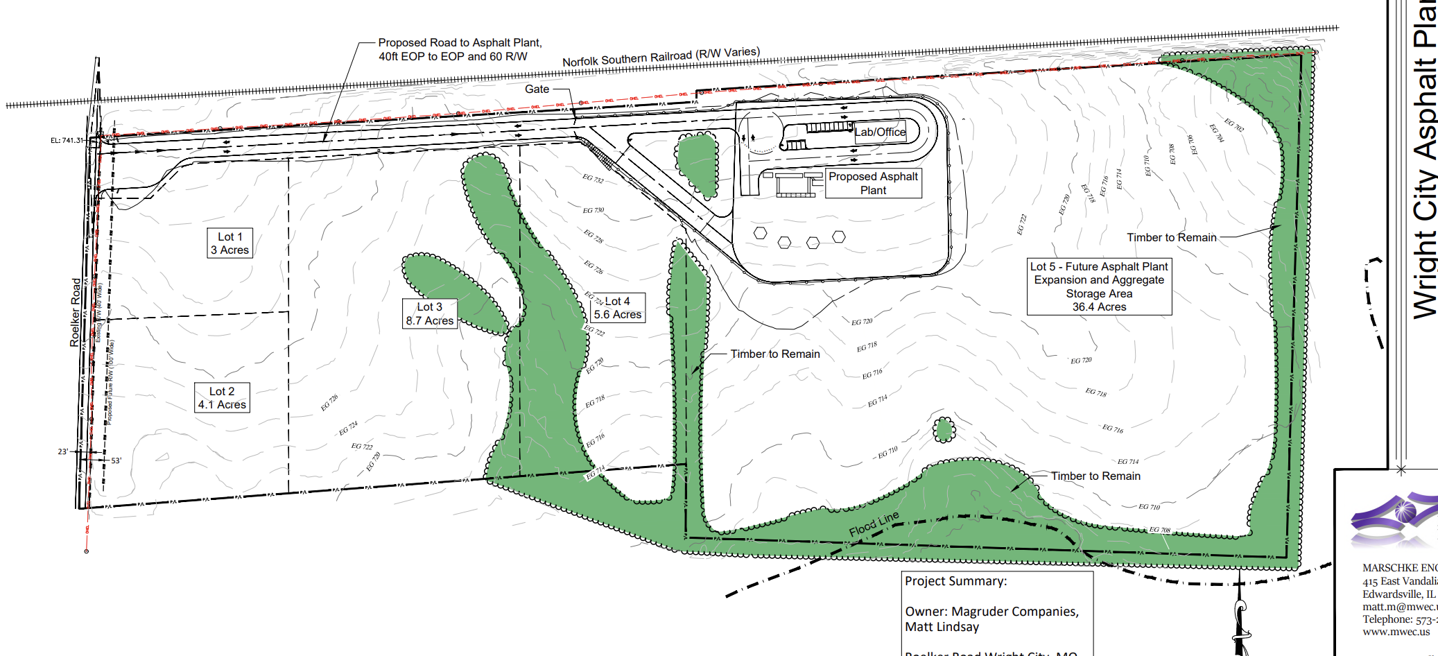
The five conceptual lots add up to the acreage the City billed
The sheet’s own Project Summary states “Total Project Area: 58 Acres” and “Current Zoning: M-1.” On June 10, 2026 the City assessed development fees of $11,600 against approximately 58 acres at $200 per acre. The next day the Board approved a site plan whose plant block is annotated “About 5 Acres,” with Condition 3 withholding approval of the future expansion and storage area entirely.
The fee was calculated on the whole project. The approval covers only the plant area — and no record states how large that area is or where it lies.
And none of these lots exist
Condition 4 of the June 11 approval states that the approval “does not approve a subdivision plat or creation of the lots shown as Lots 1-5,” and that those lots are “conceptual only.” The six underlying parcels were never consolidated. So “Lot 4, 5.6 Acres” is a label on a drawing, not a legal parcel with a recorded boundary.
That is the difficulty with every figure above. The Code measures setbacks, open storage, building coverage and height against a lot. There is no lot. The 5.6 acres has no metes and bounds, no survey, and no legal description — and the City confirmed on August 6, 2026 that it holds no document fixing where the plant area begins or ends.
The lots are shown here because they are what the sheets depict and what the fee was calculated from. They are not offered as boundaries that legally exist.
And the plant is not clearly inside either lot
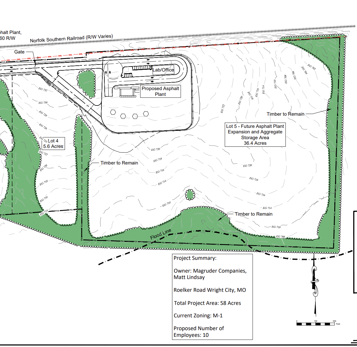
The “Lot 4 — 5.6 Acres” label sits well west of the plant. The “Lot 5 — Future Asphalt Plant Expansion and Aggregate Storage Area — 36.4 Acres” label sits east of it. The plant block and its drive loop are drawn between the two, and no dimension on the sheet ties the plant to either boundary.
So the five-acre figure cannot be checked even against the drawing. There is no dimension from the plant to a lot line, no bearing, no coordinate, and no note stating which lot the plant occupies. Reading the sheet, there is no way to determine where the approved plant area actually is.
That is the same answer the City gave in writing on August 6, 2026, when it was asked for any document fixing the plant’s location and setbacks within the lot: it was unable to determine the specific records being requested.
Two different figures, often treated as one
5.6 acres is the size of Lot 4, a conceptual lot on the preliminary plat. “About 5 Acres” is a note inside a label box on the plant block on the civil sheet. They are different numbers from different drawings, and nothing in the record states that they describe the same ground.
Neither one is a measurement of the asphalt operation. One is a lot that was never created; the other is an approximation written in a box, with no boundary drawn around it. Sheet C-4 later drew the plant, the tanks and the circulation at 1″=20′. The rest of the operation — stockpiles, unloading, loader paths — has never been drawn or measured at all, and no sheet puts a boundary around the approved area.
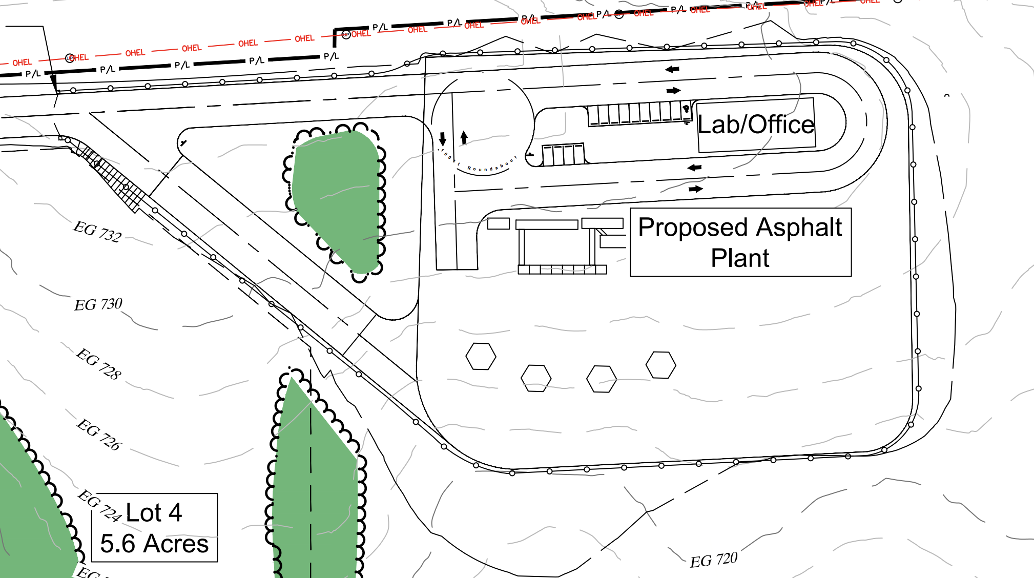
And here is the area it all has to fit inside
Civil plan set, January 29, 2026, Sheet C-1 — the set the Board approved June 11, 2026. The nearest lot label reads Lot 4 — 5.6 Acres.
Set 3 of 3
Plan set three · before Planning & Zoning for consolidation and boundary adjustment — August 17, 2026 and September 21, 2026
Site plans dated July 8, 2026
Updated copies requested — TBD
The same block on the current sheet
Revised civil plan set, July 8, 2026 — the current set, transmitted July 9, 2026. Labeled “Projected Asphalt Plant (10 Employees) [About 5 Acres].”
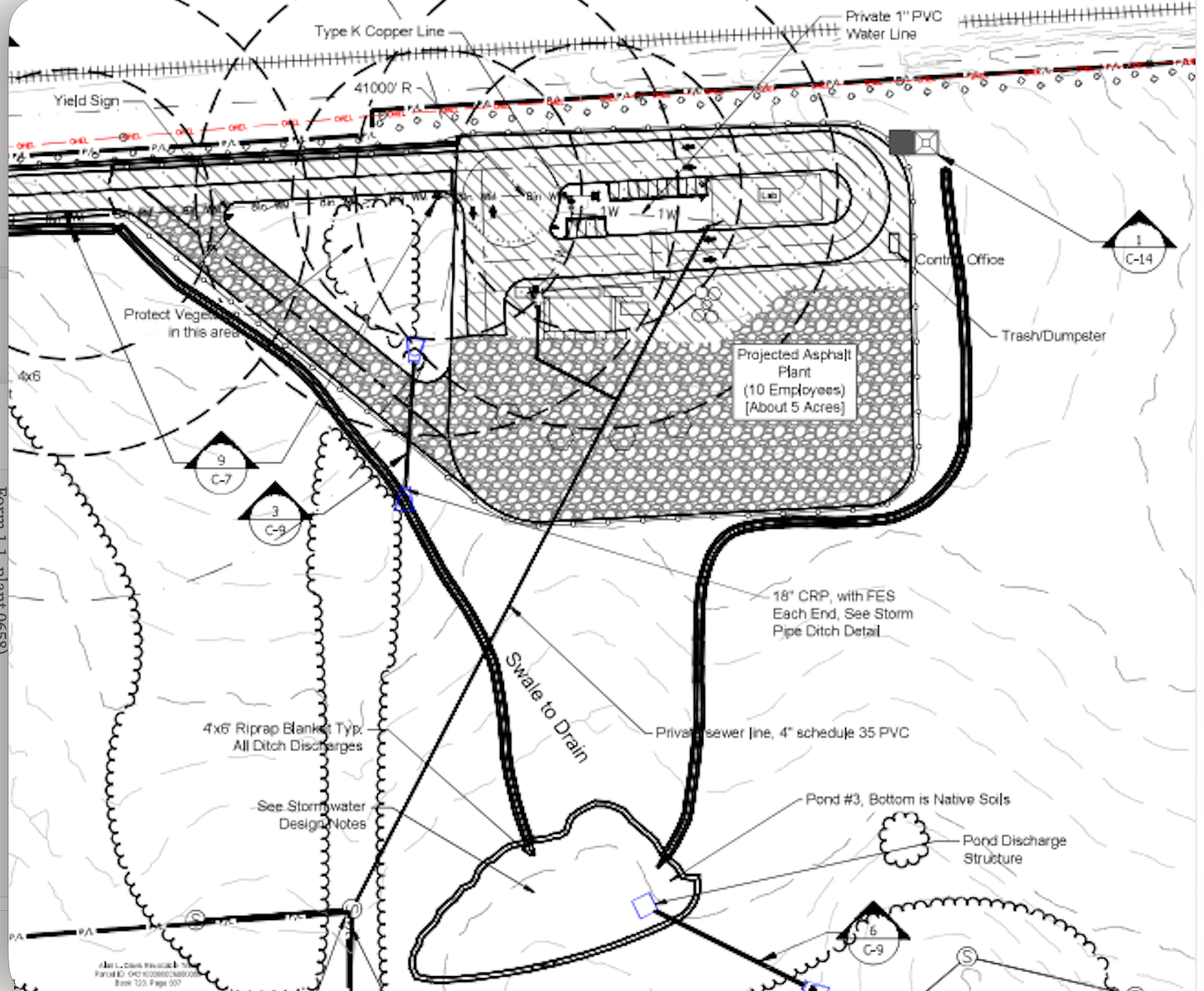
Detail from the July 8, 2026 revised set. Labels as shown on the sheet.
Open the revised civil set → The block contains the plant, a control office, a trash and dumpster enclosure, the drive loop, a swale to drain and Pond 3. No stockpile area is labeled inside it.
What the current sheet adds up to
Nothing is labeled. Sheet C-1 of the current set carries no lot numbers and no storage area, and the Project Summary still reads “Total Project Area: 58 Acres” and “Current Zoning: M-1.” The five boxes above are empty because the drawing is.
That is what Monday’s plat records: one parcel of 58 acres, with no internal line of any kind. The three sheets tell one story in three steps — a storage area named and measured, then enlarged and given a lot number, then removed.
Every sheet says 58 acres. Only the first two say where the aggregate goes — the full sequence is laid out in Section 5.
In this area the sheet places the plant itself, the lab and office building, two rows of parking, the internal drives, and a roundabout. Sheet C-4 enlarges that same block to 1″=20′ and labels the control office, the aggregate bins ramp, two conveyors, the Agg. C. Belt, an 8′ tall drum, the dust baghouse, the truck load out with scales and silo, the liquid asphalt tanks, a gravel parking lot and a gravel material haul road. What it does not place anywhere is a single aggregate stockpile or a truck unloading area for one.
Set the drawing beside Form 1.1 and the gap is specific. The plan now draws the dryer, the silo, the loadout, the tanks and the conveyors. It does not draw process points 1, 1A and 2 — Haul In Sand & Aggregate, Haul In RAP, and Stockpiles. The material the plant runs on has no place on the sheet.
The equipment is drawn. The material it runs on is not.
Sheet C-4, “Asphalt Plant Site Plan,” 1″=20′ — revised civil plan set, July 8, 2026. Title block stamped 07/08/2026.
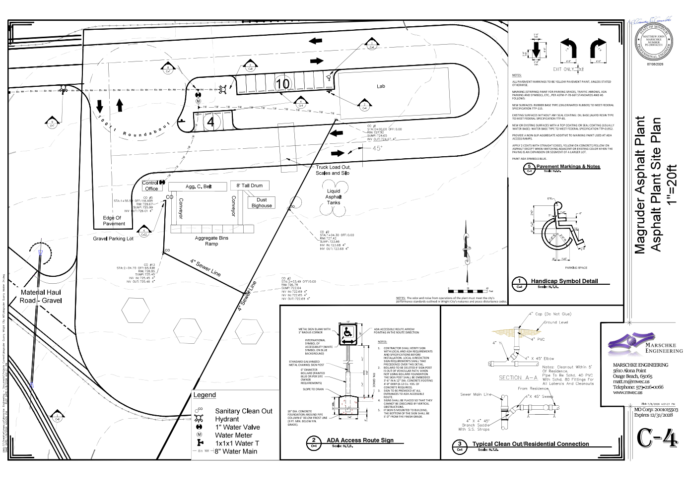
This sheet answers part of the question. At 1″=20′ it names the control office, the aggregate bins ramp, the conveyors and the Agg. C. Belt, an 8′ tall drum, the dust baghouse, the truck load out with its scales and silo, and the liquid asphalt tanks. The plant is no longer a rectangle.
It also sharpens the question it does not answer. The aggregate bins are drawn, with a ramp feeding them — but nothing on the sheet shows where the aggregate comes from. There is no stockpile, no unloading apron, and no loader path from a pile to the ramp. A route labeled “Material Haul Road – Gravel” runs off the edge of the drawing toward ground the sheet does not show.
Nor does the sheet carry the figures the Code needs. No capacity and no containment dimension beside the liquid asphalt tanks. No height on any structure except the drum. No boundary drawn around the “About 5 Acres,” and no setback dimension from the equipment to any line.
And the fuel is not on the sheet at all
C-4 labels one tank group: “Liquid Asphalt Tanks,” four circles, with no capacity, no dimension, and no containment or berm drawn around them. That is Form 1.1’s point 9A, the AC tank.
The rest of that family does not appear. Form 1.1 also lists 9B, Fuel Oil Tanks and 10, Diesel Generators. The SWPPP puts numbers on them: 15,000 gallons of burner fuel and 7,000 gallons of diesel, alongside 50,000 gallons of liquid asphalt — 72,000 gallons in total, which the SWPPP describes as held in bermed tanks.
On a sheet drawn at 1″=20′ that carries sewer invert elevations to the hundredth of a foot, 22,000 gallons of fuel and every berm around it are absent.
The question that follows: where are the fuel oil tanks and diesel generators shown on Form 1.1 drawn on this plan, and where is the secondary containment the SWPPP describes?
Condition 3 points at a lot the plat erases
On June 10, 2026, the day before the vote, the City Clerk wrote to the applicant that development fees “are assessed for the entire project area, which — as shown on the site plan — totals approximately 58 acres,” and that “the subdivision plat will formally establish Lots 1–5 as depicted on the site plan, define the road easement and property lines, and tie the back land to the recorded document.”
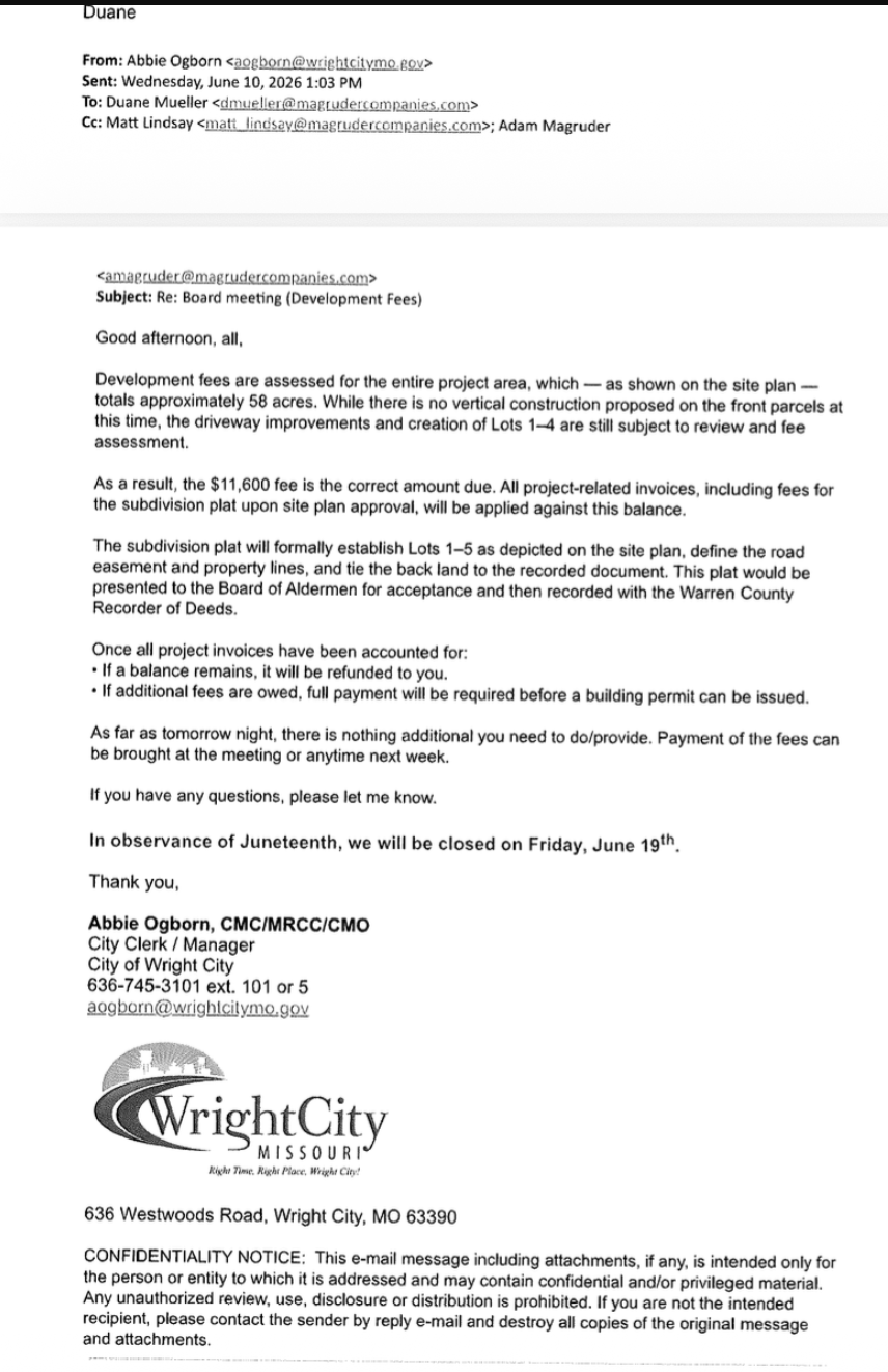
The next evening the Board did the opposite. Condition 2 directs “a boundary adjustment plat … to consolidate the existing six lots into one.” Condition 4 states the approval “does not approve a subdivision plat or creation of the lots shown as Lots 1-5” and that those lots are “conceptual only.”
So the fee was calculated on 58 acres and five lots the City said the plat would create. The approval then declined to create them and directed that everything become a single parcel instead.
On the sheet the Board acted on that night, Lot 5 was real enough to be labeled and measured: “Lot 5 — Future Asphalt Plant Expansion and Aggregate Storage Area — 36.4 Acres.” That note is precisely what Condition 3 was written to withhold.
On the current sheet, dated July 8, 2026, the note is gone. No future expansion and aggregate storage area is labeled anywhere on the property, and no replacement location appears.
Current set → ·
July 9 transmittal →That matters because of how Condition 3 is written. It withholds approval of “any future expansion or storage areas as indicated on the note on Lot 5 or otherwise.” The limit is anchored to a note on a lot.
Consolidate the six parcels into one and there is no Lot 5. The note that Condition 3 refers to is on a drawing, not on the ground, and the lot it names will not exist on the recorded plat.
The referent is disappearing twice. It was removed from the plan in July. It will be removed from the parcel map on Monday. Condition 3 will still be on the books, still withholding approval of an area that no document locates.
The petitioners ask the Commission to identify, on the plat before it, where the boundary of the withheld future expansion and storage area lies after consolidation — and if it lies nowhere, what Condition 3 restricts.
What is actually being approved on Monday
The consolidation and boundary adjustment covers all 58 acres. The stormwater system on these plans is engineered for all 58 acres. The three detention basins, the swales, the discharge structures and the flood line are drawn across the whole property, not around a plant.
But the operation is only permitted to stay inside the plant area. Condition 3 withholds approval of everything else. So the entire approval depends on one line — the line between what is approved and what is not.
That line was described aloud as eight acres. The plan says “About 5 Acres.” The plat nearest it says Lot 4, 5.6 acres, on a lot the approval says was never created. The City has confirmed it holds no record fixing where that area begins or ends.
There is no approval line.
Consolidating 58 acres into one parcel, with stormwater built for 58 acres, while the only limit on the operation is a boundary nobody has drawn, does not confine the plant. It removes the last place a limit could have been written down.
The question for the Commission
The 1.5-acre figure represents the stockpile footprint, not the total acreage necessary to operate the stockpiles. The DNR process diagram shows an active production chain requiring raw-material unloading, crushing, material transfer, loader and truck movement, plant feeding, silo loading, finished-product loadout, and supporting tanks and equipment. The revised civil site plan should therefore show the full operational working envelope, not simply an area labeled “storage.”
Sheet C-4 draws the tanks, the loadout, the feed equipment and the circulation to scale at 1″=20′. Will the revised plan also dimension the four things it leaves out — the 1.5 acres of stockpiles, the truck unloading areas serving them, the equipment that works those piles, and the loader and material-transfer paths from pile to ramp — all of which appear as numbered process points on Magruder’s own DNR Form 1.1?
4What the Code limits
§405.560(A)(5)(b) — open storage may occupy no more than 40% of the lot, and storage areas carry surfacing and drainage requirements.
§405.560 — buildings may cover no more than 75% of the lot.
§405.520 — industrial structure height. §405.540 — additional setbacks where structures exceed 30 feet and adjoin residential zoning. The only height stated anywhere in the record is the 8′ tall drum on Sheet C-4. No height is given for the silo, the stack, the aggregate bins, the baghouse or the conveyors — the structures these two provisions would actually turn on.
Setbacks drawn on Sheet C-2 — 250-foot setback lines and fire-hydrant spacing envelopes further reduce the usable interior of the site.
§405.110(C)(1) — off-street parking and loading. The main rule is unqualified: “all driveways and access points to public or private streets shall be paved.” The current sheets label a “Gravel Parking Lot” and a “Material Haul Road — Gravel,” and C-2’s Site Legend carries a “Gravel Limit.” The entrance itself is paved — C-6 specifies 2.5″ asphalt over 8″ of clean rock.
Gravel, and the four exceptions that do not reach it
The City has described §405.110(C)(1) as “the paving requirement” in its own words. Its exceptions are written narrowly, and each is checkable against this site:
Existing residential gravel driveways — not residential.
Residential driveways connected to private gravel roads — not residential.
A conditional use permit “to allow heavy steel track equipment storage on gravel” — requires a CUP, and the City has confirmed in writing that no conditional-use application exists for this project.
“Biodegradable product inventory and materials” in industrial districts — rock, sand and liquid asphalt cement are not biodegradable.
The City applied this subsection differently seven months earlier. On January 16, 2025 it published a notice, signed by the City Clerk, for a Board of Adjustment hearing held January 29, 2025: an applicant on Star Connection Drive sought
“a variance from the paving requirement of the Wright City Zoning Code, Section 405.110.C.1 … to allow gravel surfaces for a proposed asphalt batch plant.” Same code, same use type, a noticed public hearing.
Hearing notice →Which exception under §405.110(C)(1) applies here, by subsection — and if none does, how does this plat conform to the Zoning Code under §410.010(I)?
Conditions of approval are not conformity
Two different things get treated as one. Conditions 1 through 5 are what the Board of Aldermen attached to its June 11, 2026 site-plan vote — administrative conditions on that application. §410.010(I) asks a different question: does the plat conform to the Zoning Code, meaning the standards in Chapter 405.
A condition can restrict what an applicant may do. It cannot make a nonconforming feature conforming, because the standard is not the Board’s to waive. The Code names two cures, and both run through a different body, with notice and a public hearing: a variance from the Board of Adjustment, or a conditional use permit. Neither appears in this file.
Condition 3 in particular is a withholding. It declines to approve the future expansion and storage area. Declining to approve one thing is not a determination that what remains conforms.
So the conditions do not answer the question the Commission has to answer. The conformity determination required by §410.010(I) is a separate record — and the petitioners ask which document it is.
The arithmetic, done here because the City never did it
The operation needs 1.5 acres of storage piles. That is not an estimate — it is the figure in the DNR technical review for this plant at this site.
The approved area is about five acres, or 217,800 square feet. A 40% open-storage cap allows roughly 87,100 square feet. The required piles are about 65,300 square feet — 30% of the entire approved area, and three-quarters of everything the open-storage limit permits.
That leaves about 3.5 acres for the plant itself, the 72,000 gallons of tankage and containment, the lab and control offices, the scale, 14 parking spaces, the internal drives, the gate, and three stormwater basins — before a single setback is subtracted. The 250-foot setback lines on Sheet C-2 and the fire-hydrant spacing envelopes come out of that remainder.
Whether it works is a question only a dimensioned plan can answer. Sheet C-4 draws the plant equipment to scale, but it draws no boundary around the approved area and shows no stockpiles — so the percentage cannot be computed from any sheet in the file.
Current set, July 8, 2026 →This calculation is ours, from published figures. It shows what the review would have involved. It is not a substitute for one.
Now run the same arithmetic on one 58-acre lot
Monday’s plat consolidates the six parcels into a single lot. The Code’s limits are percentages of the lot. So the lot the percentages are measured against stops being five acres and becomes fifty-eight.
40% open storage
On about 5 acres
2.0 acres
On one 58-acre lot
23.2 acres
75% building coverage
On about 5 acres
3.75 acres
On one 58-acre lot
43.5 acres
The required 1.5 acres of piles
Of the 40% allowance on 5 acres
75%
Of the 40% allowance on 58 acres
6.5%
58 acres is 2,526,480 square feet. Forty percent of it is 1,010,592 square feet — 23.2 acres of open storage. Seventy-five percent is 43.5 acres of building coverage. Against the five-acre plant block the same two limits are 2.0 and 3.75 acres.
The limits themselves do not change. The lot they are measured against does — and it grows 11.6 times. Storage that would have consumed three-quarters of everything the Code allowed becomes six and a half percent of it.
This is the part that is easy to miss on Monday. The consolidation is described as a housekeeping step that creates no new approval. But every percentage limit in §405.560 is computed from the lot, and after this vote there is one lot of fifty-eight acres. Condition 3 is then the only thing standing between the operation and 23 acres of permitted open storage — and Condition 3 points at a lot number the same plat removes.
Arithmetic ours, from the Code percentages and the sheets’ own “Total Project Area: 58 Acres.” 1 acre = 43,560 sq ft. No such calculation exists in the City’s file at either lot size — the City confirmed that in writing on August 6, 2026.
5Where the future expansion and storage area went
Where the aggregate storage area went. It is labeled on the first two plan sets, grows by 3.4 acres between them, and is not shown at all on the set now before the Commission.
6/13/25
before P&Z, Aug. 18, 2025
Aggregate storage area
33 acres labeled “Future Asphalt Plant Expansion and Aggregate Storage Area”
1/29/26
approved June 11, 2026
Aggregate storage area
36.4 acres on Lot 5 — 3.4 acres larger than the set the Commission saw
7/8/26
current set
Aggregate storage area
Absent entirely. No aggregate storage area anywhere in the set, and no labeled lots on C-1 or C-2 — the plant block reads “Projected Asphalt Plant (About 5 Acres).”
The compounded label
The plans join two different things under one heading: “Future Asphalt Plant Expansion and Aggregate Storage Area.” Expansion is genuinely future. Aggregate storage is not — it is what the plant runs on from its first day of operation. Condition 3 excluded both.
The applicant’s own site map filed with the State places the stockpiles 200 feet from the plant, in the excluded area. So either the operation depends on ground the approval does not cover, or the material moves inside the five acres and the 40% calculation becomes decisive. The record resolves neither.
6What the City has confirmed it does not have
Each of these is the City’s own written answer to a Sunshine Law request.
No
40% open-storage calculation and no
75% coverage calculation — Aug. 6, 2026 response, Item 5.
Letter →No document
fixing the plant’s location or setbacks within Lot 5 — Aug. 6, 2026: “unable to determine the specific records being requested.”
Letter →No
§405.100(A)(7) desirability review — July 20 and Aug. 6, 2026 responses.
July 20 → ·
Aug. 6 →No
application, narrative, or operations description apart from the drawings — the only “application” ever produced is the plan set itself.
Letter →No
written determination identifying the M-1 basis for the use — July 2, 2026: “there are no documents related to this request.” The same subject matter was withheld as privileged on June 17.
July 2 → ·
June 17 →No final construction plans and no final SWPPP review as of Aug. 28, 2026 — the City’s engineering consultant, relayed by the Clerk. Quoted in full in Section 7 below.
7The stormwater plan is still not finished
Eleven weeks after the approval, the City’s own engineering consultant confirmed that the final plans and the final stormwater plan had never been submitted. The Clerk relayed it in writing.
BFA Engineering to the City · forwarded by the City Clerk · August 28, 2026
“It is our understanding that the developer has not yet submitted final construction plans as part of the building permit review process. As a result, BFA has not reviewed any subsequent or final SWPPP or other construction plans.”
Two things follow from that sentence. The Board approved the site plan on June 11, 2026 after being told at the meeting that “stormwater plans were reviewed by BFA and would be no impact to the creek.” And the review BFA had actually completed — its letters of February 10, 2026 — was its sixth review of a plan set that has since been revised twice.
Feb. 10, 2026 — BFA stormwater letter directs “UPDATE Sheet C-2 and C-5 with submittal of final plans.” Those final plans had still not arrived six months later.
June 11, 2026 — the Board approves the site plan; the minutes record that stormwater was reviewed and there would be no impact to the creek.
July 15, 2026 — the Building Inspector’s plat review leaves the Chapter 412 stream-buffer question open.
Aug. 28, 2026 — BFA: no final construction plans submitted, no final SWPPP reviewed.
The June 2025 SWPPP the applicant filed with the State is itself unfinished: blank facility-identification fields, undated signature lines, a blank quarter-section, “(TBD)” entries in the inspection and BMP sections, a blank Appendix 8, and future-tense notes for secondary containment and stockpile controls. It describes a 33-acre facility — matching neither the five-acre plant block nor the 58-acre project area.
The Clerk has since directed that engineering questions go to the City rather than to BFA directly, so the consultant’s answers now pass through the custodian.
Each step, and what the record shows
Every line below is the City’s own document or its own written answer to a records request.
Aug 18, 2025
The site plan is heard under New Business, with no public hearing. Two conditional use permits on the same agenda receive noticed hearings.
Apr 23, 2026
The Board amends §410.010 by Ordinance No. 1108, Bill 8-26 — the section that sets the plat sequence.
Jun 10, 2026
The City assesses development fees of $11,600 on approximately 58 acres and writes that the plat “will formally establish Lots 1–5 as depicted on the site plan.”
Jun 11, 2026
The site plan is approved. Condition 4 states the lots are “conceptual only” and were never created. No written M-1 determination exists. No conformity determination exists.
Jun 23, 2026
The consolidation plat is submitted — twelve days after the vote it was meant to precede.
Jul 8, 2026
The revised plans remove the aggregate storage area and all lot labels.
Jul 15, 2026
The §410.010(G) plat review finds the plat “appears to comply,” while leaving open an unlabeled tract, missing state-plane coordinates, tax certification, abstract of title, and the Chapter 412 stream buffer.
Aug 6, 2026
The City confirms in writing: no 40% open-storage calculation, no 75% coverage calculation, no document fixing the plant’s location or setbacks, no conditional-use application, and no permits issued.
Aug 17, 2026
The plat comes before the Commission and is tabled.
Aug 28, 2026
The City forwards its engineering consultant’s statement: no final construction plans submitted, no final SWPPP reviewed.
Sep 21, 2026
The plat returns to the Commission, with none of the above supplied.
At every step the City has been asked for the document, and at every step the answer has been that it does not exist.
Why this plat cannot be found conforming on this record
Every standard that establishes conformity is measured against a lot — setbacks, the 40% open-storage cap, the 75% coverage cap, and height under §405.520 and §405.540. The plat is what creates the lot. So the measurements can only be made against the parcel this plat records, and no measurement of any kind exists in the file for any lot configuration, past or proposed. That is the City’s own written answer, not an argument made here.
Ordinarily that loop is closed by the plat itself, which carries the dimensioned information — the boundary of the operating area, the storage location, the setbacks. This plat does not. The Building Inspector’s July 15, 2026 review under §410.010(G) flagged the same class of defect: an unlabeled tract, missing state-plane coordinates, and an unresolved Chapter 412 stream buffer.
On one standard the record is not merely silent. §405.110(C)(1) requires paving; the sheets show a gravel parking lot and a gravel material haul road; and there is no variance and no conditional use permit. That is not an open question. It is a nonconformity on the face of the drawing, and a condition of approval cannot cure it.
The fuel cannot be resolved either, and for a reason that compounds the rest. §405.510(A)(5) treats the storage of flammable gases and liquids as a conditional use rather than a use permitted by right. Which of the three stored liquids falls inside that provision depends on what each one is — its flash point and its classification. The record does not identify them. The plan sheet labels one tank group and gives no capacity; the 15,000 gallons of burner fuel and 7,000 gallons of diesel appear on no sheet at all. Without knowing the fuel type, neither the storage nor the proceeding it belonged in can be determined — by the Commission, by staff, or by anyone reading the file.
Approving the plat does not resolve any of this. It records a 58-acre parcel that has never been measured against the Code.
There is also a question of order. §410.010 sets the sequence: the boundary-adjustment plat goes to the Commission for review and recommendation, and is approved and recorded, before a site plan resting on the consolidated lot is acted upon. That provision was not overlooked through age — the Board amended §410.010 by Ordinance No. 1108, Bill 8-26, on April 24, 2026, seven weeks before the June 11 approval. The site plan was approved first anyway. The consolidation plat followed twelve days later, reached the Commission on August 17, 2026, and was tabled.
That is why the conformity determination cannot be read back into the June 11 vote. At that point there was no lot to measure against. Monday is the first moment the lot and the conformity question exist at the same time.
The short of it
An asphalt plant was approved as a use permitted by right on an area the City cannot locate, with storage the plan does not show, no height stated for any structure but an 8′ drum, no tank capacity or containment shown, and no boundary drawn around the approved area nor any setback dimension from the equipment to a line — against limits nobody calculated.
This is what the zoning-conformity requirement of §410.010(I) is supposed to address — and cannot, if this last step approves it. Once the plat is approved, conformity is assumed for what is still a conceptual asphalt plant on conceptual lots.
Read the records yourself
Every document cited on this page is published in full. Nothing here is summarized without the source behind it.
Sources: Magruder SWPPP, June 2025, §3.1 and Appendix 2 · DNR Portable Source Relocation Request PORT-0658, Feb. 24, 2025, including the Form 1.1 process-flow diagram and the submitted site map · DNR Authorization 032010-001AK, Mar. 12, 2025, technical review · Magruder civil plan sets dated June 13, 2025, January 29, 2026 and July 8, 2026 · Wright City Board of Aldermen minutes and conditions, June 11, 2026 · Planning and Zoning Commission minutes, Aug. 18, 2025 · City of Wright City Sunshine Law responses of June 17, July 2, July 20 and Aug. 6, 2026 · Wright City Code §§405.510, 405.520, 405.540, 405.560. Every document cited is published at wright-city-neighbors.netlify.app.